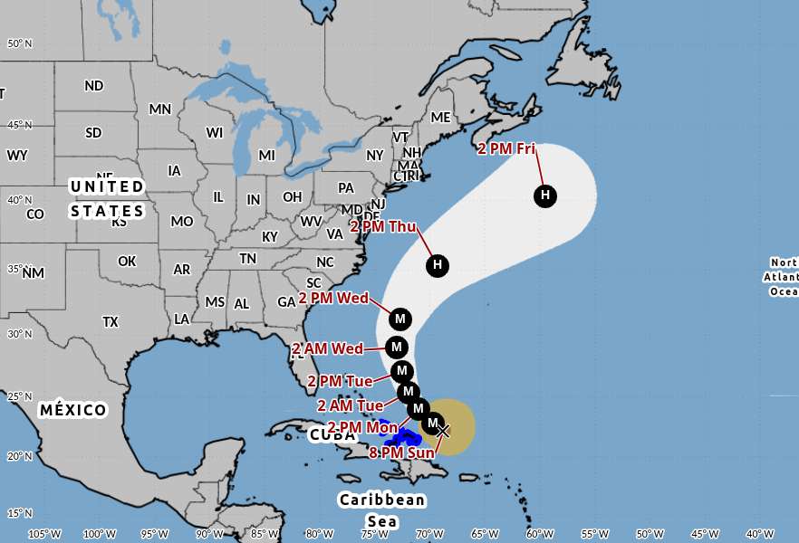
Hurricane Erin remains a powerful Category 3 storm and is forecast to intensify further as it shifts toward the open Atlantic, according to the latest update from the National Hurricane Center (NHC).
As of the 5 p.m. advisory, Erin was sustaining maximum winds of 125 mph, classifying it as a major hurricane. The system is expected to grow in size and maintain major hurricane strength through at least midweek.
Warnings in Place
Tropical Storm Warnings remain in effect for the Turks and Caicos Islands and parts of the southeastern Bahamas. The NHC projects that Erin will track northeast of these regions tonight into Monday, sparing them a direct hit but still bringing gusty winds and rough seas.
Forecast Path
The hurricane is expected to gradually curve northwest on Monday before turning northward by Tuesday. Longer-term forecasts show Erin continuing northward between Bermuda and the Outer Banks of North Carolina.
Because of its increasing size, both Bermuda and coastal North Carolina could experience effects from the outer bands of the system later this week.
Coastal Impacts in Florida
While Erin is not projected to make landfall in Florida, the storm will generate significant ocean swells and dangerous rip currents along the state’s east coast starting Monday. Forecasters expect the most hazardous surf conditions Tuesday into Wednesday, with waves reaching 6 to 9 feet and the potential for beach erosion during high tide cycles.
In addition, drier air moving in from Erin’s circulation is expected to lower rain chances across Florida on Tuesday and Wednesday.
Staying Informed
Residents along the southeastern U.S. coast and Bermuda are urged to monitor updates closely as Hurricane Erin continues to move north. The NHC will issue updated advisories as new data becomes available.

Comments